Good GPS and navigation tools don’t just make hunting easier. They keep you alive out there. We’ve talked to hunters across the country to figure out what actually works when you’re miles from the nearest road and your phone shows zero bars.
REI’s gear experts put it perfectly: “a handheld GPS receiver remains a valuable outdoor tool for hikers and other backcountry explorers—giving you vital information about where you are, where you’ve been, and where you want to go.”
Here’s what we’ll cover to get you navigating like a pro:
- GPS apps versus dedicated devices (and when each makes sense)
- Must-have features that actually matter in hunting situations
- Complete gear setup for backcountry safety and success
Whether this is your first time hunting unfamiliar ground or you’re finally upgrading from that old paper map system, the right preparation makes the difference between a great story and a scary one.
Know Before You Go: Essential Prep
The fanciest GPS won’t save you if you’re hunting where you shouldn’t be or you’re unprepared for what the backcountry throws at you. Smart prep work is what makes all your tech actually useful when things get real.
Regulations Check
Hunting rules change faster than you’d think, and they’re different everywhere you go. What’s legal in your home state might get you in serious trouble two states over. Experienced hunters know this well: “knowing where property lines are and where you are legal to hunt is of high importance when hunting unfamiliar territory.”
If you’re hunting out of state, double-check everything. Season dates, shooting hours, weapon restrictions, access rules—it all varies. Some GPS apps now show hunting boundaries and regulations right on the map, which is incredibly handy. But always verify through the official state wildlife website before you go. Rules change between seasons, and ignorance isn’t a defense.
License and Tag Acquisition
Get your paperwork sorted early, especially for non-resident hunts or limited tags where everyone’s competing for the same spots. Pro tip: some GPS apps let you store digital copies of your licenses for quick access during game warden checks.
Physical & Gear Readiness
Backcountry hunting is physically demanding, and your gear needs to match that reality. Navigation tools are just one piece of a larger safety system that keeps you oriented and secure when you’re far from help.
The Gear Advantage: Why GPS and Navigation Tools Matter Now
Backcountry navigation has changed dramatically over the past decade. Outside Magazine notes that “over the past ten to fifteen years, backpacking has become increasingly high-tech.” This tech revolution directly solves three major problems every backcountry hunter faces.
Getting lost in unfamiliar country isn’t just inconvenient—it’s dangerous, especially if you’re hunting solo. Accidentally crossing onto private land can end your hunt instantly and create legal headaches. And poor navigation wastes precious hunting time when you should be focused on finding game.
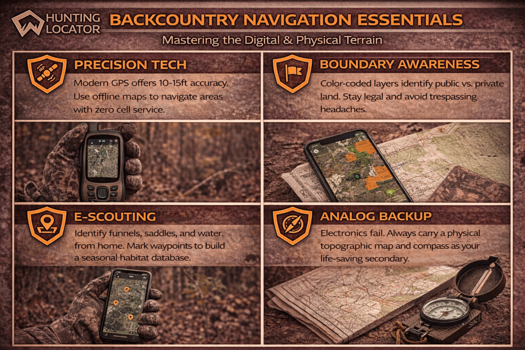
Current GPS technology delivers “accuracy within 10-15 feet” under normal conditions. That precision, combined with detailed maps and boundary data, completely changes how you can approach unfamiliar hunting areas.
GPS Apps vs. Dedicated Handheld Devices
This is probably the biggest decision you’ll make for backcountry navigation. Both options work, but the right choice depends on how you hunt, what you’re willing to spend, and how much risk you’re comfortable with.
| Factor | GPS Apps (Phone-Based) | Dedicated Handheld GPS |
|---|---|---|
| Cost | Subscription-based ($30-$100/year) | One-time purchase ($200-$700+) |
| Battery Life | Limited by phone battery; requires backup power | Extended battery life; some offer 200+ hours |
| Durability | Depends on phone case; touchscreen issues with gloves | Built for outdoor conditions; physical buttons |
| Offline Maps | Available with most hunting apps | Standard feature |
| Hunting Features | Excellent (boundary layers, unit info, landowner data) | Varies by model; some lack hunting-specific layers |
| Weight | No additional weight if already carrying phone | Additional device to carry |
| Emergency Communication | Requires cell service (unless paired with satellite device) | Some models include satellite messaging/SOS |
The good news about phone apps is that goHUNT confirms “maps can be downloaded for use when you’re headed to an area void of cell service,” which addresses the main concern about relying on your phone in remote areas.
For dedicated units, Field & Stream found the Garmin GPSMAP 66i “serves its purpose flawlessly from the Rockies to the Midwest hardwoods to the dense forests of the East.”
Features That Actually Matter for Hunting
GPS companies love to pile on features, but most of them don’t matter when you’re actually hunting. Focus on the stuff that genuinely helps in the field:
Must-Have Features:
- Offline map capability: Absolutely essential for backcountry hunting where cell service is spotty or nonexistent
- Public/private land boundaries: onX makes this point clearly – “color-coded public and private land ownership boundaries allow you to quickly and easily find accessible public land”
- Waypoint marking: For tagging stands, vehicles, camps, and harvest locations
- Battery life/power options: Critical for multi-day hunts
- Durability and weather resistance: Must survive drops, rain, and temperature swings
- Topographic detail: Essential for understanding terrain and planning approaches
Nice-to-Have Features:
- Track logging for recording your routes
- Weather overlays
- Hunting unit regulation integration
- Landowner contact information
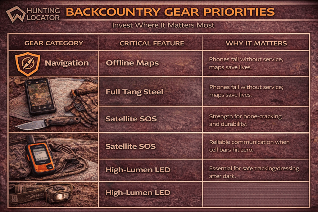
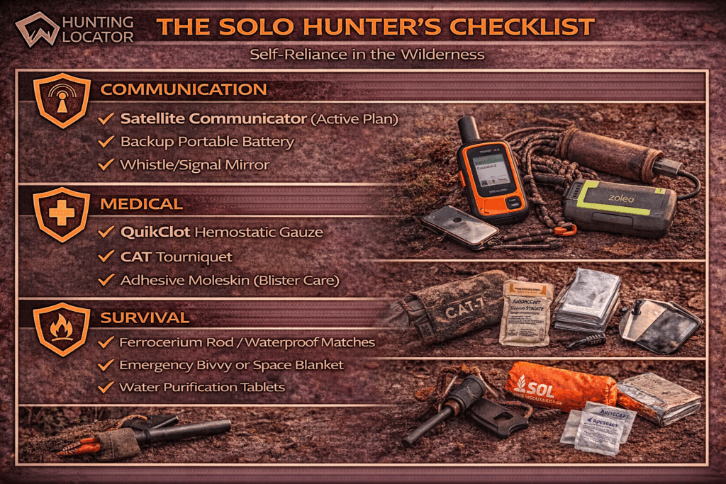
Satellite Communicators: The Safety Backup
Devices like Garmin inReach and Zoleo provide emergency communication and location sharing when you’re completely out of cell range. They add cost and weight, but for serious backcountry hunting—especially solo trips—the safety value often justifies the investment.
Ready to check out GPS options? Browse our GPS and Navigation collection to find what works for your hunting style and budget.
Scouting & Habitat: Using GPS for Pre-Hunt Preparation
E-scouting might be the most valuable thing you can do with modern GPS technology. Being able to study terrain, identify good habitat, and plan your approach before you ever step foot in new country is a game-changer. goHUNT explains it well: “e-scouting is an essential tool for out-of-state hunters, allowing them to step into a unit the first time already feeling like they know it to some extent.”
You can identify terrain features that funnel game—saddles, benches, water sources. Find access points to public land. Mark potential stand sites or glassing spots. Plan approach routes that keep you downwind and out of sight. All from your couch, weeks before your hunt.
Once you’re on the ground, mark everything important: tracks, rubs, scat, feeding areas. GPS waypoints let you return to productive spots and build a database for future hunts. The combination of pre-hunt map study and on-ground waypoint marking means less time wandering and more time in places where animals actually are.
When you’re ready to carry all that scouting intel into the field, a good hunting backpack becomes crucial for organizing and protecting your navigation gear.
Core Gear Checklist: Our Top Recommendations
Your navigation tools work best as part of a complete backcountry system. These recommendations come from what hunters actually use and trust when conditions get tough and everything needs to work perfectly.
Navigation & Safety Essentials
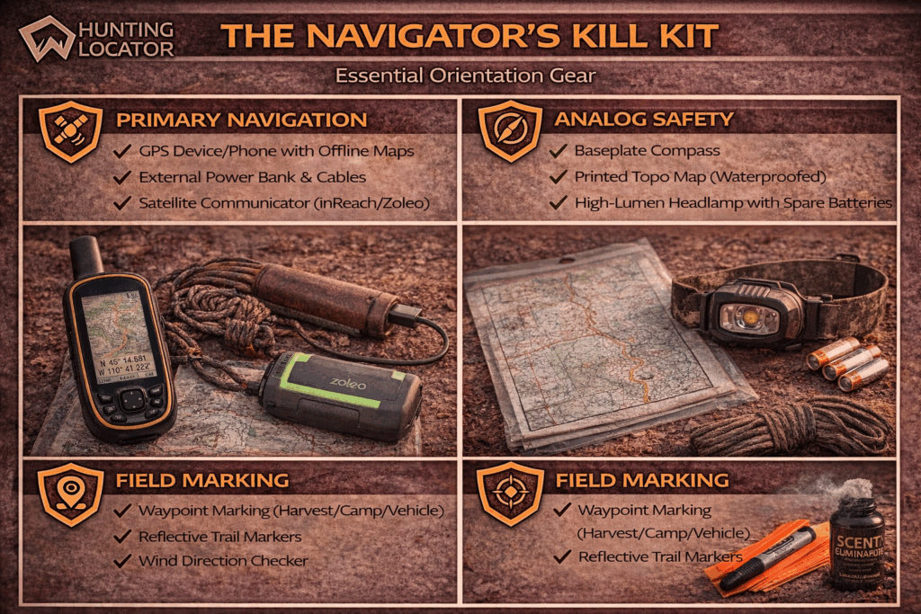
Navigation gear is the foundation of backcountry safety, but it’s most effective when it’s part of a complete preparedness system. REI has a crucial warning here: “don’t buy a GPS receiver with the idea of ditching your map and compass. Finding your way out of the wilds isn’t something you can trust solely to battery-operated electronics.”
Essential Navigation Checklist:
- GPS device or smartphone with hunting app (offline maps downloaded)
- Backup compass and paper topographic map
- Headlamp or flashlight for navigating in low light
- First aid kit appropriate for backcountry injuries
- Emergency shelter/fire-starting capability
Check out our GPS and Navigation collection for devices that handle backcountry abuse, and browse our Flashlights and Headlamps for reliable low-light navigation. For comprehensive emergency prep, explore our Survival and First Aid selection.
Field Processing & Recovery Tools
Good navigation includes being able to mark and return to harvest locations. When your hunt succeeds, you need reliable tools for field processing and getting your game out.
Field Processing Essentials:
- Sharp, dependable hunting knives for field dressing
- Game processing gloves for sanitary handling
- Headlamp for working in low light
- Waypoint marking for exact harvest location
Quality processing tools ensure you can handle your harvest efficiently and navigate back to marked spots without problems. Our Game Processing collection has everything you need for proper field care.
Stealth & Approach Gear
Effective navigation includes moving quietly and staying undetected during your approach to hunting areas.
Stealth Essentials:
- Scent elimination products for managing human odor
- Face paint for visual concealment
- Shooting sticks or bipods for stable shots
- Hearing protection for safe shooting
Comfort & Endurance Gear
Extended backcountry hunts require gear that keeps you comfortable and effective through long days in challenging conditions.
Comfort Essentials:
- Hand warmers for cold weather functionality
- Quality optics for glassing distant terrain
- Scents and lures for attracting game
- Gun cleaning kits for maintaining equipment
Tactics & Strategy: Hunting with GPS Confidence
GPS technology changes hunting tactics by giving you precise location data and terrain analysis capabilities. Understanding peak activity times, wind patterns, and approach strategies becomes much more effective when you have accurate navigation backing you up.
Peak Activity Times and GPS Tracking
Most game species follow predictable activity patterns at specific times of day. GPS waypoint marking lets you document successful observation times and locations, building a database of productive spots. You can use GPS to “compass mode to easily find your way back to camp in the dark, pinpoint and mark that bedded mule deer before a stalk, or mark your animal’s location after the shot for an easy and worry-free recovery hike.”
Wind & Scent Control Strategy
GPS helps you plan approach routes that work with prevailing wind directions and terrain features. By marking successful approaches and noting wind conditions, you can develop location-specific strategies for different weather patterns.
The Approach: GPS-Assisted Positioning
Whether you’re planning stand placement, still-hunting routes, or calling positions, GPS technology lets you scout and mark optimal locations during pre-season prep. Customizable waypoints, lines, and tracks “help you map out every detail of your hunt.”
Post-Harvest Care: The Work After the Shot
Good navigation doesn’t stop when you pull the trigger. It helps you efficiently recover your harvest and get it safely out of the field.
Tracking & Recovery
GPS waypoint marking is incredibly valuable for blood tracking and recovery. Mark your shooting position, where the animal was when you shot, and key points along the blood trail. This systematic approach ensures you can retrace your steps if needed and helps other hunters assist with recovery.
Field Dressing
Proper field dressing requires good lighting and sharp tools. Your navigation system should include reliable lighting for working in low-light conditions and waypoints marking your processing location for easy cleanup and gear retrieval.
Transport & Processing
GPS tools help you plan the most efficient route from harvest location to your vehicle, considering terrain difficulty and distance. Mark your vehicle location before the hunt to ensure you can navigate directly back with your harvest.
More Resources from Hunting Locator
Expand your hunting knowledge and preparation with these additional resources from our platform:
- Hunting Lease Database – Find private land hunting opportunities across all 50 states with detailed property information and landowner contacts
- Public Land Maps – Access comprehensive mapping tools showing hunting unit boundaries, access points, and regulation information
- Outfitter Directory – Connect with professional guides and outfitters for destination hunts and local expertise
- Product Reviews – Read detailed reviews and comparisons of hunting GPS devices, apps, and navigation accessories
- Gear Guides – Species-specific equipment recommendations and seasonal gear checklists for different hunting scenarios
- Hunting Regulations Database – State-by-state regulation summaries with links to official wildlife agency resources
FAQ
What’s the difference between hunting GPS apps and regular navigation apps?
Hunting GPS apps include specialized features like public/private land boundaries, hunting unit information, landowner contact details, and offline mapping optimized for remote areas. Regular navigation apps focus on roads and trails rather than property boundaries and hunting-specific information.
How much should I expect to spend on a reliable GPS setup for hunting?
GPS app subscriptions typically cost $30-$100 annually, while dedicated handheld units range from $200-$700+. Budget options like HuntStand offer “$30 access to all 50 states.” Consider your hunting frequency and areas when budgeting—occasional hunters often find apps sufficient, while serious backcountry hunters may prefer dedicated devices.
Do I really need offline maps if I’m hunting areas with cell service?
Yes, even areas with cell service can have dead zones, and battery drain increases significantly when your device constantly searches for signal. As experts recommend, “maps can be downloaded for use when you’re headed to an area void of cell service,” ensuring navigation capability regardless of connectivity.
How accurate are GPS devices for marking property boundaries?
Modern GPS devices provide “accuracy within 10-15 feet” under normal conditions. However, property boundary data accuracy depends on the mapping service’s survey information. Always respect posted signs and landowner wishes, as GPS boundaries serve as guides rather than legal definitions.
Should I carry backup navigation tools with my GPS device?
Absolutely. REI emphasizes that you shouldn’t “buy a GPS receiver with the idea of ditching your map and compass. Finding your way out of the wilds isn’t something you can trust solely to battery-operated electronics.” Always carry a compass and paper topographic map as backup.
How do I practice using GPS technology before my hunting trip?
Navigation experts recommend practicing “skills before heading into the backcountry in a familiar area that has obvious features to catch mistakes.” Start by using your GPS device in familiar hunting areas, practice waypoint marking, and learn to navigate using both GPS and traditional methods.
The Final Shot
Solid navigation transforms backcountry hunting from a risky gamble into a confident pursuit of game in remote country. The right GPS tools, combined with proper preparation and backup methods, keep you safe, legal, and focused on what you came for—the hunt itself.
Modern technology has solved many traditional navigation problems, but success still comes down to choosing the right tools for how you hunt and learning to use them effectively. Whether you go with a smartphone app or dedicated handheld device, the key is building a complete navigation system that works reliably when everything depends on it.
Ready to gear up for your best backcountry season yet? Visit our store today! We stock the best GPS devices, navigation accessories, safety equipment, and field processing tools to ensure your success in the backcountry.